Residents of southern Montana and northern Wyoming can look forward to a gentle transition from lingering winter moisture to a milder, drier pattern that will dominate the forecast through the first week of November. After a brief spell of rain and mountain snow Monday night, the region will settle into clear skies, modest temperatures and very low precipitation chances.
Monday Night
Rain and mountain snow will gradually taper off from west to east this evening. The Bighorn Mountains may still experience blowing snow, creating challenging travel conditions on higher passes. Gusty winds of 25‑45 mph across the eastern plains will also subside, though patchy fog could develop overnight from Livingston eastward, reducing visibility in parts of southern Montana and northern Wyoming.
Tuesday
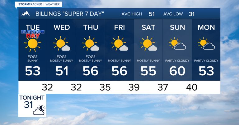
Morning commuters should watch for fog and low clouds, especially in valleys. By mid‑morning the fog is expected to lift, leaving a dry and quiet day. High temperatures will generally sit in the upper 40s to low 50s, with Billings around 53 °F and Sheridan climbing into the mid‑50s.
Wednesday
Dry weather continues with a mix of clouds and sunshine. Temperatures remain seasonable, with highs near 51 °F in Billings and Miles City and the mid‑50s around Sheridan.
Thursday
High pressure builds, keeping the area dry while temperatures begin to rise. Expect highs in the mid‑ to upper‑50s across south‑central and southeast Montana and northern Wyoming.
Friday
The mild, mainly dry pattern holds. A weak disturbance may bring a few mountain showers, but precipitation chances at lower elevations stay very low. Highs will generally be in the mid‑ to upper‑50s.
Saturday
Another mostly dry day is forecast. Early‑November warmth persists, with highs ranging from the lower to upper 50s.
Sunday
Temperatures climb further, with widespread highs in the 50s and low 60s. Billings could reach around 60 °F, while southeast Montana moves into the low 60s and Sheridan may see mid‑60s. Dry weather should continue.
Monday (Next Week)
The mild pattern extends into the start of next week. Highs are expected to reach the upper 50s to low 60s across south‑central and southeast Montana, with northern Wyoming potentially hitting the mid‑60s again. Precipitation chances remain very low.
Overall, the forecast offers a welcome respite from winter storms, providing comfortable conditions for outdoor activities and travel throughout the Billings area and surrounding communities.
Original reporting: KTVQ Q2 Billings (local) — read the source article.