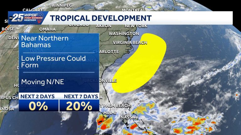
The National Hurricane Center (NHC) is monitoring a non‑tropical low‑pressure system that is expected to develop near the northern Bahamas this weekend. While the chance of the system becoming a named storm is low, forecasters note a slight possibility of subtropical development as it moves northward or northeastward toward the southeastern United States.
Forecast details
According to the NHC, the probability of formation within the next 48 hours is near 0 percent. Over the longer seven‑day outlook, the chance rises modestly to about 20 percent. The system is projected to stay offshore or near the coast, potentially bringing periods of rain and breezy conditions to Florida’s Atlantic shoreline.
What residents can expect
Florida’s coastal communities should prepare for brief showers and gusty winds, especially in the northern and central parts of the state. The NHC does not anticipate severe weather, but local officials recommend staying informed through official channels. Residents can check the WPBF 25 News app for real‑time alerts and updates.
Safety recommendations
Even with a low formation probability, it is prudent to secure outdoor items, avoid unnecessary travel on the water, and keep an eye on local weather broadcasts. The NHC will continue to issue advisories if the system shows signs of strengthening.
Local response
Florida’s emergency management agencies are on standby, ready to coordinate with county officials should conditions worsen. The focus remains on public safety and ensuring that any potential impacts are communicated quickly to the public.
For the most current information, tune in to WPBF 25 on television, radio, or online, and consider downloading the WPBF 25 News app for push notifications.
Original reporting: WPBF (Treasure Coast / Hearst) — read the source article.