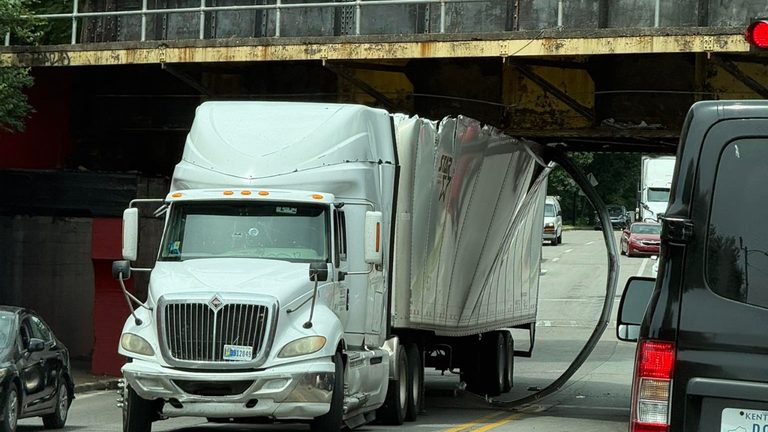
Louisville will receive a $2 million federal grant to modernize the infamous Can Opener corridor, a longtime trouble spot where low‑clearance overpasses and flooding have led to repeated vehicle strikes. The award comes from the Department of Transportation’s SMART grant program, which approves fewer than 10 % of applications, underscoring the significance of the city’s selection.
Local leaders outline the technology plan
In an interview with WLKY, Selva Oz, the assistant secretary for research and technology at the U.S. Department of Transportation, and Chris Seidt, Louisville Metro’s chief information officer, explained how the funding will be used. Louisville Metro Technology Services, in partnership with Public Works and other city agencies, led the grant application.
Seidt said the project will deploy enhanced, dynamic signage that can change in real time based on conditions in the corridor. “If it’s flooding, signs will change to address that. If it’s an over‑height vehicle, it will address that to the driver of that vehicle and try to give them a detour to go out of the area,” he explained.
Addressing more than just over‑height crashes
The technology‑based approach is designed to tackle multiple problems that have plagued the Can Opener area, including recurring flooding that often obscures signage and creates hazardous driving conditions. Existing static signs have proven insufficient, as drivers become accustomed to them and ignore warnings, especially when operating larger trucks or rental vehicles.
“People get used to what’s in the built environment, right? So they drive past those signs today, they drive past them every day,” Seidt said. “Then they rent a truck to move a family member and go through that same corridor, not thinking about what’s in that area that they need to pay attention to.”
Why a costly bridge raise isn’t the solution
City officials have fielded questions about why Louisville cannot simply raise the railroad bridge or lower the road to eliminate the clearance issue. Seidt noted the engineering challenges and expense: “You have to go back several thousand feet in each direction to raise that much rail up, and there’s a lot of critical infrastructure buried in that area, like sewer and water lines, that would have to be relocated. It’s a very expensive endeavor.”
Potential national impact
Oz highlighted that successful implementation could serve as a model for similar corridors nationwide. “If this technology works here, it will be adopted in other similar environments and scenarios throughout the country,” she said.
The formal announcement is scheduled for 10 a.m. on Tuesday, when Mayor Craig Greenberg will join Oz and Seidt to unveil the project and discuss next steps.
What this means for Louisville families
For everyday commuters and families, the new system promises safer travel through a corridor that has long been a source of frustration and danger. By providing real‑time alerts for flooding and over‑height vehicles, the city aims to reduce accidents, protect motorists, and keep local businesses accessible.
Mayor Greenberg emphasized the administration’s commitment to practical, technology‑driven solutions that improve quality of life without imposing new taxes on residents. “We’re leveraging federal resources to make our streets safer and more efficient for all Kentuckians,” he said.
Original reporting: WLKY Louisville — read the source article.