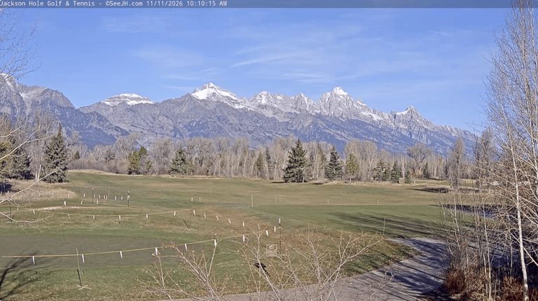
Jackson, WY – The Tetons are off to a sluggish start this winter. Despite a wet October, above‑average temperatures this fall and a dry early November have produced a meager snowpack. On November 11, the snow depth at Jackson Hole’s upper mountain measured just six inches, matching the low of 2011 and representing the shallowest reading in the last 25 years.
Current conditions
High pressure over the interior West has kept the region sunny and warm, while the storm track sits farther north over Washington and British Columbia, delivering rain rather than snow to those areas. Valley highs have lingered in the 50s for a week and even reached 60°F on Sunday and Monday, with lows in the low 20s. Overall, November temperatures in Jackson are running 6.6°F above average.
Snow coverage remains limited below 10,000 feet, appearing only on north‑facing slopes and shaded terrain between 9,000 and 10,000 feet. The sheltered Rendezvous Bowl Plot at 9,580 feet holds six inches of snow, far below the 21‑inch average for this date.
Historical perspective
Early‑season snowpack data before 2000 is sparse, but snow‑water‑equivalent records from Phillips Bench and Togwotee Pass suggest the last comparable low occurred in November 1999, when both sites reported zero snow. The average first snowfall in Jackson falls on October 16, meaning the season is already at least a month delayed.
The most recent early‑season snowfall lag was December 3, 2007, a year that ultimately delivered a record‑breaking winter with over 600 inches recorded at the Raymer Plot.
Looking ahead
Forecasts show two chances for mountain snow over the next seven days, though both appear to be light events. Thursday and Friday will likely be the last unseasonably warm days, with valley highs in the upper 50s. A weak storm is expected Saturday, bringing light rain to the valley and light snow to the mountains, with snow levels around 7,000‑8,000 feet and valley highs in the 40s.
Another system may arrive Tuesday night, but its center will track well south of the Tetons, suggesting another modest snowfall. A cold front on Tuesday afternoon could finally bring the first accumulating snow to the valley, though the precipitation looks light and may be followed by a drying trend.
Beyond the week, models hint at a possible storm around November 19‑20 with enough cold air for snow at valley levels, offering the best chance for a meaningful snowfall in the next 10‑14 days. NOAA’s 8‑14‑day outlook calls for near‑normal temperatures later in November, which will feel considerably colder than the recent warm spell, and a slight increase in precipitation.
Alan Smith, Meteorologist
Original reporting: Buckrail (Jackson WY) — read the source article.