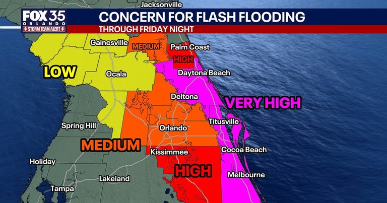
Central Florida residents, including those in Orlando, are bracing for a prolonged deluge as a potent weather system is forecast to deliver as much as 20 inches of rain, raising the risk of severe flash flooding through Friday. The National Weather Service has placed most of the region on a flood watch from Tuesday afternoon through Friday, covering Brevard, Indian River, Orange, Osceola, Seminole and Volusia counties.
According to Fox 35, meteorologist Noah Bergren said the first wave of rain will arrive between 9 p.m. Wednesday and 2 p.m. Thursday, producing flash flooding in Brevard, Osceola and Volusia counties overnight into Thursday morning. A second band of heavy precipitation could follow Thursday night into Friday morning, with wind gusts up to 50 mph.
The FOX 35 Storm Team estimates the highest totals will be in Brevard, eastern Osceola, eastern Orange and southern Volusia counties, where 12 to 20 inches of rain is expected, with locally higher amounts possible. Coastal communities such as Titusville, Cape Canaveral, Cocoa Beach and Melbourne are also projected to exceed the 12‑to‑20‑inch range. Inland areas—including Daytona, Oviedo and St. Cloud—could see 8 to 12 inches, while the Disney World and Universal Orlando resort areas are expected to receive 4 to 8 inches. Further west, Gainesville and Ocala may get 1 to 4 inches.
WOGX echoed the flood watch details, noting flash flooding is likely in Brevard, Volusia and Flagler counties, where rapid water rises could creep into neighborhoods and homes over the next three days. The flood risk remains critical through Friday, especially in low‑lying and poorly drained locations.
Beyond the immediate rain threat, forecasters are watching the system for possible development into a tropical or subtropical storm off the Atlantic coast over the weekend. Bergren explained that warm ocean temperatures of up to 82 °F could allow the system to organize into a named storm—potentially Tropical Storm Kyle—by Saturday. If it forms, the outer bands could bring gusty winds, rough surf and beach erosion to East Coast counties Saturday into Sunday.
Local emergency management officials are urging residents to avoid driving through flooded roadways, secure loose outdoor items and stay tuned to local weather updates. The flood watch remains in effect through Friday, and residents should monitor any updates regarding the potential naming of the system as Tropical Storm Kyle.
What’s next: Continue to follow local forecasts as the rain bands move eastward. The flood watch stays active through Friday, and the National Hurricane Center will issue any advisories if the system organizes into Tropical Storm Kyle over the weekend.
Sources: fox35orlando.com, wogx.com