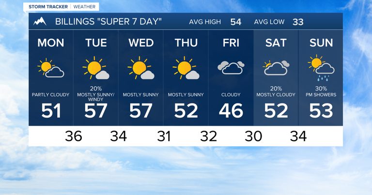
Residents of the Billings area should prepare for a mixed precipitation pattern early Monday. An upper‑level low moving out of the region will drop a rain‑snow mix across eastern portions of the city before transitioning to all snow near the Montana‑North Dakota border early this morning. A low probability of patchy freezing drizzle is also expected across Fallon and Carter counties through sunrise.
Morning Fog and Early‑Day Temperatures
Fog is likely to develop Monday morning, especially in river valleys and other low‑lying spots that have absorbed recent moisture. Daytime highs on Monday will sit in the 40s and 50s, providing a cool start to the week.
Tuesday’s Upper Trough and Mountain Snow
By Monday afternoon, a stronger, fast‑moving upper trough will surge into the northern Rockies, bringing a broader chance of precipitation across the region through early Tuesday afternoon. Model guidance suggests most areas will see less than a tenth of an inch of liquid equivalent, while western counties could approach a quarter of an inch.
Higher elevations will receive the most snow. The Beartooth, Absaroka, and Crazy Mountains are projected to accumulate a few inches above 7,000 feet, while the Pryor and Bighorn ranges could see about an inch. Tuesday’s system will also generate breezy conditions, with sustained winds of 25 to 45 mph and gusts of 35 to 50 mph expected over the western foothills.
Temperatures on Tuesday will generally be in the 50s, offering a modest warm‑up after Monday’s cooler start.
Mid‑Week Calm and Weekend Outlook
Wednesday and Thursday are expected to be relatively quiet, featuring plenty of sunshine and daytime highs in the mid‑50s. As the work week progresses, the flow aloft will shift to a southwesterly pattern, allowing occasional lower‑elevation rain and mountain or foothill snow to return.
Friday’s highs will be in the mid‑40s to low 50s, with the weekend returning to milder conditions and highs generally in the mid‑50s.
What Residents Can Do
Motorists should allow extra travel time on Monday morning, especially on routes that cross river valleys where fog may reduce visibility. Those traveling to higher‑elevation areas should be prepared for a few inches of snow and gusty winds on Tuesday.
For the latest updates, keep an eye on local forecasts and heed any winter weather advisories issued by the National Weather Service.
Original reporting: KTVQ Q2 Billings (local) — read the source article.