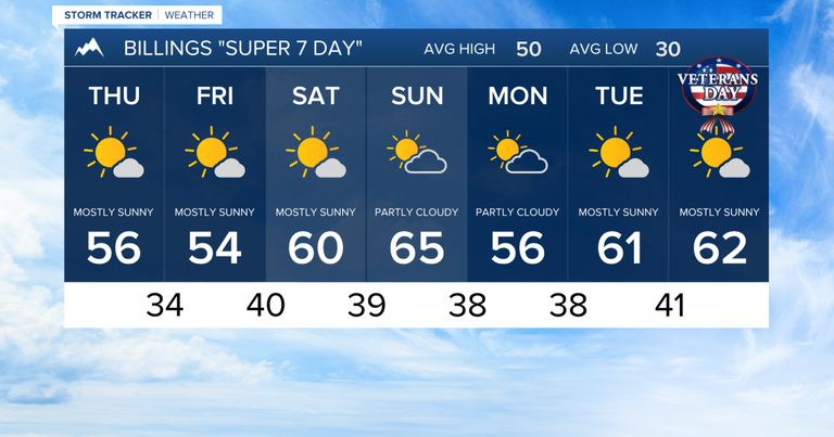
Residents of Billings and the surrounding Billings area can expect a relatively calm weather pattern over the next seven days, with mostly mild temperatures and limited precipitation.
Fog and sunshine early in the week
Thursday morning may bring patchy fog in low‑lying areas and river valleys, while a second bout of fog could develop late Thursday night into early Friday morning, particularly around Miles City. Aside from these brief fog periods, the forecast calls for plenty of sunshine on Thursday and Friday, with daytime highs generally ranging from the mid‑ to upper‑50s and occasional low‑60 °F readings.
Friday’s shortwave disturbance
A weak, mostly dry shortwave disturbance will move through the region on Friday. The western mountains could see a very slight chance of light snow, and the lower elevations west of Billings may experience a few rain showers. Winds are expected to pick up along the western foothills starting Friday morning, with gusts of 30‑40 mph possible, especially from Big Timber to Harlowton.
Gusty winds over the weekend
By Saturday, gap‑flow winds are projected to strengthen around the Livingston area, with gusts exceeding 50 mph through Sunday. These stronger winds will be most noticeable in the foothill corridors and may bring occasional dust or debris.
Warmer weekend temperatures
Temperatures will rise over the weekend. Saturday highs are forecast in the upper 50s to low 60s, while Sunday will see mid‑ to upper‑60s, with some spots flirting with 70 °F.
Looking ahead to next week
The overall pattern remains quiet heading into the following week. A few weak disturbances could pass through, bringing on‑and‑off light rain showers and breezy conditions, with highs staying in the 50s and 60s.
For those planning outdoor activities, the mild temperatures and mostly dry conditions provide a pleasant backdrop, though it’s wise to stay alert for gusty winds, especially in the foothill regions.
Original reporting: KTVQ Q2 Billings (local) — read the source article.