Residents of Billings and the surrounding south‑central and southeast Montana region can expect a shift from today’s strong winds to a period of light snow beginning Friday and lasting into Saturday. While Thursday will be relatively calm, the upcoming storm system brings the first real snowfall opportunity of the season for many local communities.
Thursday – Calm Before the Snow
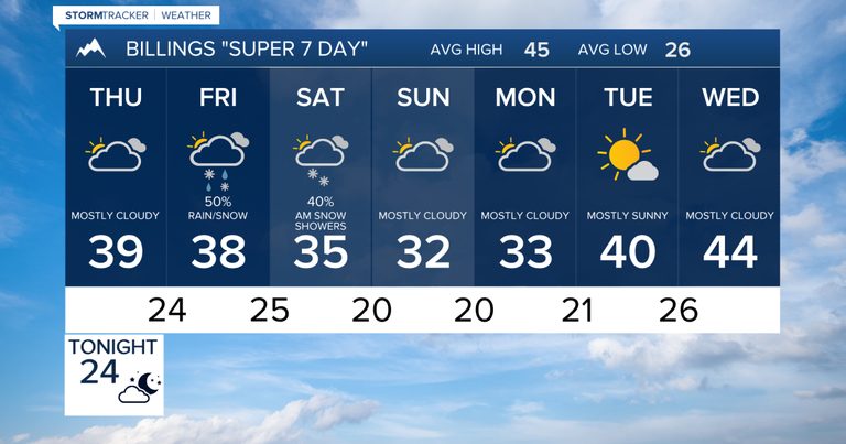
Thursday’s weather will be considerably quieter. Winds will ease, and precipitation will be minimal to none. Temperatures will remain chilly, generally topping out in the upper 30s to mid‑40s Fahrenheit. Morning fog may develop in parts of south‑central Montana, potentially reducing visibility for commuters.
Friday – Fog Followed by Snow Chances
Early Friday could see another round of fog, especially in low‑lying areas. By mid‑day, a new storm system will begin to affect the region, increasing snow chances across south‑central and southeast Montana as well as northern Wyoming. Temperatures will stay in the upper 30s, and the lift associated with the approaching system should allow snow to become more widespread. Accumulations are possible, though exact amounts remain uncertain at this stage.
Saturday – Potential for Widespread Snowfall
Saturday offers the best opportunity for accumulating snow. A developing low‑pressure area to the southeast will generate north‑to‑northeast winds, enhancing snowfall along foothill regions through upslope flow. Most areas have a chance of receiving measurable snow, and Billings could see its first one‑inch snowfall of the season. Limited moisture in the system means overall totals should stay modest.
Sunday – Scattered Showers Remain Possible
The main storm system will pull away Saturday evening, but an upper‑level disturbance lingering over Montana may keep scattered snow showers possible through Sunday. Any additional accumulations are expected to be light. Afternoon highs will remain near 30 to the lower 30s, with overnight lows dropping into the teens and lower 20s.
Monday Through Wednesday – Cold Conditions Continue
Cold weather will linger into Monday before temperatures gradually moderate on Tuesday and Wednesday. Highs are expected to climb back to the 40s by mid‑week. The overall pattern remains active heading toward Thanksgiving week, though confidence in the timing and impacts of individual systems stays low. Travelers should continue monitoring forecasts as the holiday approaches.
What Residents Should Do
Motorists are advised to allow extra travel time on Friday and Saturday, especially on routes that traverse foothill areas where upslope snow may be heavier. Keep an eye on local road‑condition updates and consider using chains or winter tires if conditions deteriorate. Parents should plan for possible school delays or closures, and anyone with outdoor activities should dress warmly and stay informed of any sudden changes in visibility due to fog.
Overall, the upcoming weekend brings a welcome chance for snow in a season that has been dry so far, while temperatures stay comfortably cold for winter recreation and holiday preparations.
Original reporting: KTVQ Q2 Billings (local) — read the source article.