Florida’s east‑coast communities faced a historic deluge Friday as record‑breaking rain forced airboats onto streets and sent the St. Johns River soaring past a high‑water mark not seen since 1953. The storm system, intensified by an El Niño pattern, dumped more than 17 inches of rain on parts of the coastline since Tuesday, shattering November’s typical dry‑season expectations.
Widespread flooding and emergency response
From south of Melbourne up to Jacksonville, a 200‑mile stretch was placed under flood watches and warnings. The National Weather Service warned of an additional 2‑6 inches of rain through Saturday, with isolated pockets potentially receiving up to a foot of fresh downpour. “Severe, widespread flash flooding is expected,” the service cautioned, noting that areas unaccustomed to flash floods would be affected and that lives and property were in great danger.
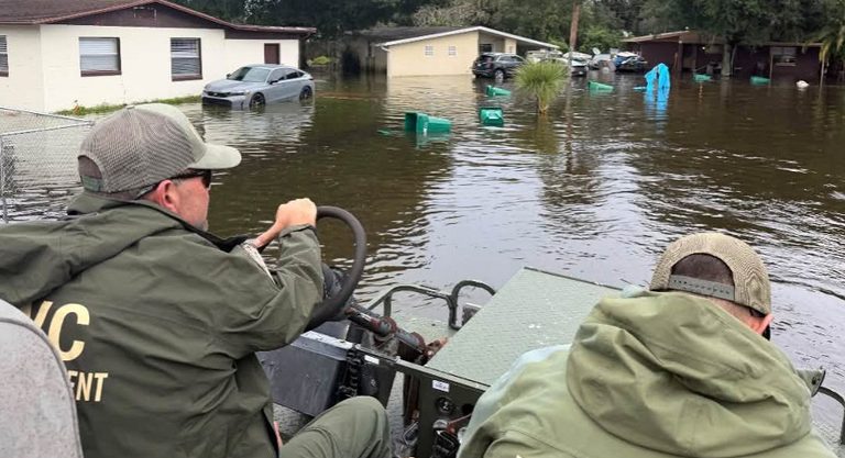
Local police in Edgewater’s Florida Shores neighborhood waded through knee‑deep currents, towing a small boat to ferry residents to dry ground. In Brevard County, first responders completed nearly 100 high‑water rescues on Thursday alone, using airboats to navigate submerged neighborhoods and check on stranded families.
The Division of Emergency Management bolstered efforts with nearly 200 Florida National Guard troops and 50 high‑water vehicles moving up and down the coast. About 235 officers from the Florida Fish and Wildlife Conservation Commission also joined the rescue operations, providing additional manpower and expertise.
River levels and future outlook
The surge pushed the St. Johns River, the state’s longest waterway, past a high‑water mark near Cocoa that had not been reached since 1953. Forecasters expect the river to remain at least two feet above flood stage into early next week, keeping many riverside neighborhoods on high alert.
Beyond the immediate crisis, the storm is projected to track northeast, bringing heavy rain to the Georgia and Carolina coasts over the weekend, according to AccuWeather. A second Atlantic system could develop into a subtropical or tropical storm, potentially delivering additional rain, strong winds and dangerous surf from the Southeast up to New England early next week. A third potential coastal storm is also being monitored for mid‑week formation.
Broader weather patterns
While November normally falls within Florida’s dry season (October through May), meteorologists attribute this week’s washout to a strong El Niño event, which shifts global weather patterns and is expected to persist through the spring. A persistent high‑pressure ridge over Virginia combined with a Gulf low‑pressure system and a stationary front funneled a steady “firehose” of moisture onto the peninsula.
In addition to the east‑coast flooding, California’s coast experienced its own deluge, with heavy rain flooding neighborhoods between Los Angeles and San Francisco, prompting drivers to abandon stalled cars and causing rock and mudslides that shut down a long stretch of Highway 1 south of the Monterey Peninsula.
What residents can do
Authorities urge residents in affected areas to stay informed through local weather updates, avoid driving through flooded roads, and heed evacuation orders when issued. Those needing assistance can contact local emergency management offices or the Florida National Guard’s disaster response hotline.
As the community rallies to support one another, the coordinated response of police, fire, National Guard and wildlife officers underscores Florida’s commitment to protecting families and property during extreme weather events.
Original reporting: Tampa Free Press — read the source article.