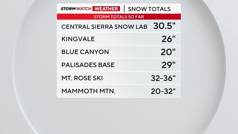
Winter weather has taken a dramatic turn for the Truckee Meadows and the Sierra Nevada this week. Since the storm began Thursday morning, ski areas such as Mt. Rose and Palisades have reported roughly three feet of fresh snow, a substantial accumulation in a short period.
Snow totals and precipitation
Both resorts posted their latest figures on their websites, and while an official consolidated report is still pending, the numbers are clear: the high country is enjoying a deep snowpack that will benefit skiers and snowboarders throughout the holiday season. In contrast, the valley received lighter amounts, with rain dominating the precipitation type.
Reno–Tahoe International Airport recorded about one inch of liquid precipitation so far. Historically, the airport’s first measurable snowfall of .01″ or more typically arrives around Thanksgiving, making this early event noteworthy for residents who are still adjusting to the season.
Road conditions and safety warnings
Forecasting winter weather in the Truckee Meadows remains complex. Early Thursday morning, a brief warm layer near the surface at roughly 4,500 feet allowed temperatures to hover in the lower‑ to mid‑30s, keeping many roadways wet. Around 9:30 a.m., a heavier rain burst turned to snow, creating slick spots that persisted through the morning commute.
The foothills received at least double the precipitation measured at the airport, and officials expect icy conditions to return overnight. Friday morning lows are projected to fall into the teens and 20s, meaning any remaining puddles will freeze quickly. Drivers should watch for ice patches during the evening commute, especially on hill climbs and side streets.
Upcoming showers and future storms
A modest wave of moisture will move through late Thursday into Friday, bringing light snow showers to the Sierra and northern Nevada north of I‑80. While these showers won’t add significant depth, even a dusting can make roads slick, particularly if ice lies beneath the fresh snow.
Looking ahead, another storm system is expected on Sunday, followed by a third on Tuesday. The Sunday system appears weaker but could still produce a dusting to an inch of snow in valley locations, while the Sierra may see an additional 3‑6 inches. The Tuesday storm is still too far out to predict exact totals, but the pattern suggests the “storm gate” will stay open, allowing cold air to remain in place.
What residents can do
Local authorities advise motorists to reduce speed, increase following distance, and avoid sudden braking on potentially icy surfaces. Keeping an emergency kit in the vehicle—including blankets, water, and a flashlight—remains a prudent precaution during these fluctuating conditions.
For the latest updates on road conditions, residents can monitor the Nevada Department of Transportation’s website or follow local news outlets. Staying informed and prepared will help keep families safe as the region navigates this active winter weather pattern.
Original reporting: 2news.com — read the source article.