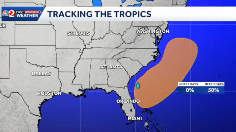
The National Hurricane Center (NHC) is closely monitoring a low‑pressure area that has settled off the east coast of Florida on Wednesday. According to the agency’s 7 p.m. update, the system is expected to move toward the northern Bahamas and could become a subtropical or tropical storm as it tracks northward or northeastward along the southeastern United States coastline through the weekend.
Formation odds and timeline
The NHC’s latest outlook shows a 0 % chance of development in the next 48 hours, but the probability rises to 50 % over the next seven days. Forecasters will continue to watch the disturbance as it drifts across the western Atlantic, noting that even without full cyclogenesis, the area will generate strong winds, dangerous surf and the potential for coastal flooding.
Local impacts in Florida
Florida’s east coast is already experiencing heavy rain that has caused flooding from Miami northward to Volusia County. The First Warning Weather team, which includes chief meteorologist Tony Mainolfi, attributes the current rain to the same low‑pressure system that could later develop into a subtropical or tropical storm. Rainfall is expected to persist through Friday before the system lifts northeastward, easing the immediate flood threat but leaving lingering water concerns in low‑lying neighborhoods.
Broader regional threat
Regardless of whether the system intensifies, the NHC warns that strong winds, dangerous surf and coastal flooding are likely along portions of the southeast and mid‑Atlantic coasts into early next week. Residents from the Florida panhandle to the Virginia shoreline should monitor local forecasts, secure loose outdoor items, and consider sandbagging vulnerable properties.
What residents can do
First Warning Weather advises Floridians to stay tuned to local updates on WESH 2, both on‑air and online, for the most accurate forecasts. The station’s news app provides real‑time alerts, allowing families to prepare for sudden changes in wind or water levels. Homeowners are encouraged to review flood insurance coverage, especially in areas that have seen repeated inundation during recent rain events.
Looking ahead
The NHC will issue further advisories as the system evolves. If the disturbance does become a named storm, federal and state emergency management agencies stand ready to coordinate response efforts, ensuring that resources reach affected communities quickly. In the meantime, the focus remains on public safety, preparedness and keeping families informed.
For continuous updates, follow the First Warning Weather team on social media and keep the WESH 2 News app installed on your mobile device.
Original reporting: WESH Orlando — read the source article.