With an unusually warm winter on the horizon, Bismarck families and commuters need clear information about the various forms of winter precipitation that can affect daily life. While many still picture a classic snow‑covered landscape, the atmosphere can produce several other types of moisture that have distinct impacts on travel, safety and outdoor activities.
How All Winter Moisture Begins as Snow
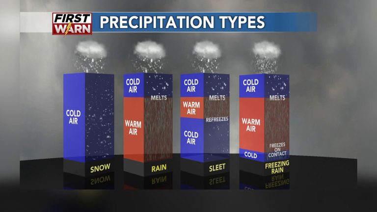
At cloud level, every winter precipitation particle starts as a snowflake. Whether that snow reaches the ground depends on the temperature profile between the cloud and the surface. If the air stays below freezing all the way down, the snow remains solid and lands as the familiar white blanket.
When Warm Air Melts Snow into Rain
In many winter storms, a layer of warm air sits beneath the cloud base. As snowflakes fall through this pocket, they melt into liquid droplets and continue to the surface as rain. This is the most common scenario when a mild air mass moves over the region.
Sleet: Ice Pellets from Refreezing Rain
Sometimes an inversion occurs—a situation where temperature actually rises with height. This creates a warm layer aloft and a colder layer near the ground. Snow melts into rain in the warm zone, then refreezes as it passes through the colder air just above the surface, producing small ice pellets known as sleet. Sleet can make roads slick and is often mistaken for light hail.
Graupel: Soft, Hail‑Like Pellets
Graupel also begins as snowflakes, but as they descend they encounter supercooled water droplets. These droplets freeze onto the snow crystal, forming a soft, rounded pellet that looks like tiny hail. Graupel falls more like snow than ice, but its texture can be noticeably different.
Freezing Rain: A Hazardous Blend
The most dangerous winter precipitation is freezing rain. This occurs when a substantial warm layer melts snow into rain, but a thin, very cold pocket sits just above the ground. The rain reaches the surface still liquid, then freezes on contact, creating a glaze of clear ice on roads, sidewalks, trees and power lines. Even a light coating can lead to treacherous driving conditions and widespread power outages.
Black Ice: The Invisible Threat
Black ice is the term locals use for a thin, transparent layer of ice that forms on roadways. It is difficult to see because it blends with the pavement, making it a hidden danger for drivers, especially during early morning or late‑evening periods when temperatures dip below freezing.
El Niño’s Influence on Our Winter
Strong El Niño events, like the one currently influencing the Pacific, typically bring warmer and drier winters to the Upper Midwest. While this may mean fewer heavy snowfalls, it also raises the likelihood of freezing rain events as warm air overrides a shallow cold layer near the surface. Residents should stay prepared for sudden icy patches even when overall snowfall is below average.
Practical Tips for Bismarck Residents
- Check the National Weather Service forecasts for temperature profiles, not just surface temperatures.
- Allow extra travel time when freezing rain or sleet is predicted.
- Keep a winter‑ready emergency kit in your vehicle, including blankets, a shovel and non‑slippery footwear.
- Consider using sand or kitty litter on driveways to improve traction if black ice is expected.
- Stay informed about local road‑closure updates from the North Dakota Department of Transportation.
Understanding the science behind each type of winter precipitation helps Bismarck residents make safer choices on the road and enjoy the season with confidence, even when the weather takes an unexpected turn.
Original reporting: KFYR-TV Bismarck (news) — read the source article.