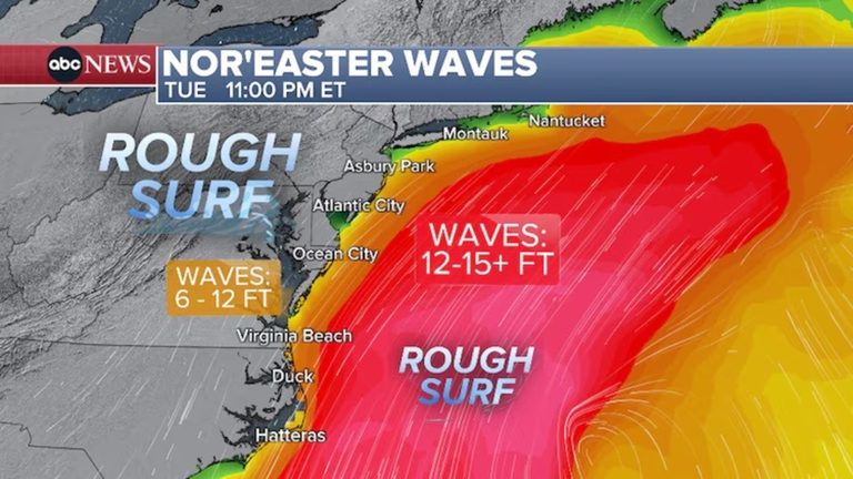
A slow‑moving October nor’easter is bearing down on the Mid‑Atlantic coast, bringing a multi‑day threat of high winds, large breaking waves, and dangerous rip currents. Coastal flood alerts are now in effect through Tuesday for Virginia, Maryland, New Jersey, North Carolina, and Delaware.
Wind and wave expectations
Forecasters say the storm will be primarily a wind and wave event, with most of the rain staying offshore. Sustained northeast winds of 25‑35 mph are expected along the coastal stretches of Virginia and North Carolina, with gusts that could reach 50 mph. Large breaking waves ranging from nine to twelve feet are possible for parts of the Outer Banks and along the Delmarva Peninsula from Virginia to Delaware through early Thursday.
Coastal flooding and beach erosion
Minor to moderate coastal flooding is likely, especially at high tide, in several coastal cities including Atlantic City, New Jersey, and Virginia Beach, Virginia. The combination of high tides, strong onshore winds, and elevated wave heights raises the risk of beach erosion and inundation of low‑lying areas.
Evacuations and travel impacts
Mandatory evacuation orders have been issued for Hatteras Island in North Carolina. Dare County Emergency Management warned that heavy traffic is already clogging Highway 12 as residents and visitors obey the order. “Visitors are not permitted to enter Hatteras Island at this time and will not be allowed to return until the storm system has passed and conditions along N.C. Highway 12 have improved to the point that the roadway is no longer threatened by ocean overwash,” the agency said.
Wind advisories have also been posted for portions of coastal Virginia and North Carolina, including Virginia Beach and the Northern Outer Banks, Hatteras Island, and Ocracoke Island.
Safety recommendations
Officials urge residents and beachgoers to heed all evacuation orders and avoid the shoreline during high‑tide periods. Life‑threatening rip currents have been reported, and swimmers should stay well away from the water until conditions improve. Motorists should allow extra travel time and consider alternate routes if possible.
The storm is expected to linger into the middle of the week, stretching its impacts across the region. While the bulk of the precipitation will remain offshore, the sustained wind and wave action will continue to pose hazards to coastal communities.
Looking ahead
Weather services will continue to monitor the nor’easter and provide updates on wind speeds, wave heights, and flood risks. Residents should stay tuned to local news outlets and official emergency management channels for the latest guidance.
Original reporting: Allentown News – 6abc Philadelphia — read the source article.