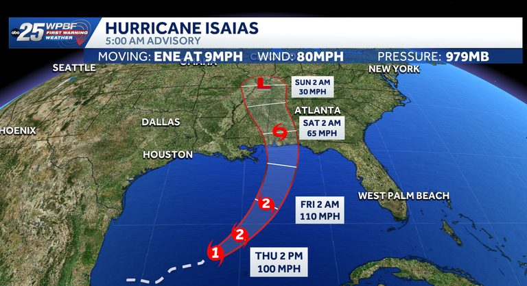
Hurricane Isaias, the inaugural hurricane of the 2026 Atlantic season, is gaining strength as it tracks east‑northeast toward the northern Gulf Coast. At 5 a.m. EDT, the storm was located about 170 miles northwest of Progreso, Mexico, and roughly 420 miles south‑southwest of the mouth of the Mississippi River, moving at 9 mph with maximum sustained winds of 80 mph.
Urgent Calls for Residents to Secure Property
NOAA’s Hurricane Hunters confirmed the storm’s intensification, prompting a direct appeal to Gulf‑coast communities. “Preparations to protect life and property from storm surge and damaging winds along the warning area of the Gulf Coast should be rushed to completion today,” the agency said. The warning area stretches from the mouth of the Mississippi River to the Steinhatchee River in Florida, encompassing coastal towns in both Mississippi and the Florida Panhandle.
Forecasted Impacts
The National Hurricane Center (NHC) projects Isaias will make landfall late Friday or early Saturday, likely north of the Yucatán Peninsula before striking the U.S. northern Gulf Coast. Expected rainfall ranges from three to seven inches across the central Gulf Coast, with isolated totals up to ten inches. Areas from far‑southeastern Louisiana to the Florida Panhandle could see significant flooding, while the Southeast, extending to the Tennessee Valley and the Carolinas, may receive one to three inches of rain, with localized amounts up to five inches.
These rains raise the risk of flash and urban flooding, as well as isolated river flooding. Storm‑surge warnings are in effect from the Mississippi River mouth to the Steinhatchee River, and a hurricane warning covers the stretch from Ocean Springs, Mississippi, to the Bay/Gulf County line in Florida.
Official Watches and Warnings
- Storm Surge Warning: Mouth of the Mississippi River to the Steinhatchee River, FL
- Hurricane Warning: Ocean Springs, MS, to the Bay/Gulf County Line, FL
- Tropical Storm Warning: Jefferson/Plaquemines Parish Line, LA to west of Ocean Springs, MS; East of Bay/Gulf County Line to Aucilla River, FL
- Storm Surge Watch: Steinhatchee River to Yankeetown, FL
Isaias was previously classified as Tropical Depression Nine and Invest 92‑L while moving through the southwestern Gulf. The system is now a Category 1 hurricane, the threshold for which is sustained winds of 74 mph.
Historical Context
Isaias marks the latest‑forming first hurricane on record, surpassing a 1905 storm that reached hurricane status on October 7, a time when satellite monitoring was not yet available. Only the 1907 and 1914 seasons failed to produce a hurricane.
What Residents Should Do
Local emergency managers advise securing loose outdoor items, reinforcing windows and doors, and having evacuation routes planned. Residents should monitor local media, follow updates from the NHC, and keep emergency kits stocked with water, non‑perishable food, flashlights, batteries, and necessary medications.
Stay tuned to WPBF 25 for continuous coverage, and consider downloading the WPBF 25 News app for real‑time alerts.
Original reporting: WPBF (Treasure Coast / Hearst) — read the source article.