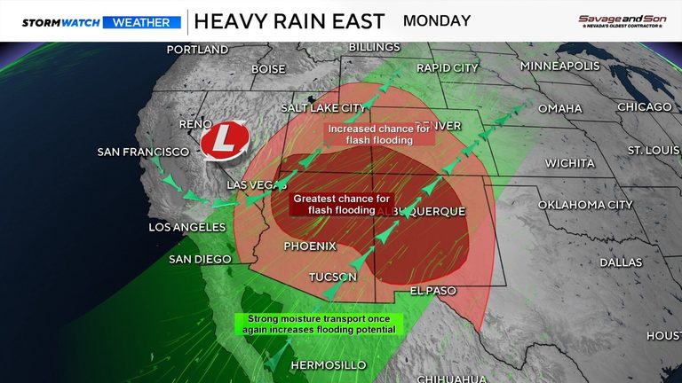
Heavy rain is only a state away from Nevada as the remnants of Hurricane Polo are expected to move into the Desert Southwest this week. An area of low pressure is also headed toward Las Vegas Monday, keeping most of the rain east of Reno.
Monday rain outlook
Areas along and east of US‑95 saw some rain on Monday, though the Reno Airport reported no measurable totals. As the low moves southeast, showers will wrap around it, with rain bands ahead of and behind the system. Most of the rain will fall in far‑eastern Nevada Monday afternoon.
Lows move in a counter‑clockwise fashion, and when enough moisture is present, rain can fall on the backside of the low as well. This brings showers in from the northeast, moving them southward. Light snow is even possible Monday afternoon in Mono County at or above 9,000 feet.
Rain totals and radar estimates
Rain totals vary, with no official measurement at the Reno Airport. Radar estimates suggest around an inch of rain over some spots in the past 24 hours, but these are not official reports. Heavier bands fell just east of Reno, resulting in light overall rain with pockets of narrow, heavier bands.
Central Nevada is a ways from the Reno radar, so totals could be skewed.
Tuesday and beyond
Skies will clear Monday night as the low exits Nevada, leaving a beautiful day on Tuesday. However, the remnants of Hurricane Polo will move into the Southwest on Tuesday and combine with the low moving through Nevada, bringing very heavy rainfall to New Mexico and Arizona. Flood watches extend north to parts of Iowa, where inches of rain could also fall.
Our extended forecast trends drier than average as high pressure takes over beginning Wednesday and remains for a while. Expect a hot start to October with highs well into the 80s, typical of the season’s mix of warm and cold days as the atmosphere transitions toward winter.
Original reporting: 2news.com — read the source article.