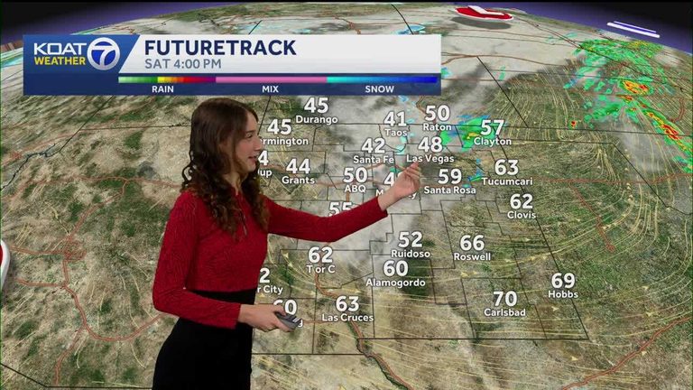
Albuquerque and Santa Fe residents should prepare for a wintry mix of rain and snow moving into the area today. The precipitation is expected to arrive around 10 a.m. and spread eastward by early afternoon, bringing a brief period of mixed precipitation that could affect travel and outdoor plans.
Temperature outlook
High temperatures will hover around seasonal averages, with Albuquerque reaching a high of 50 °F and Santa Fe a high of 42 °F. Overnight lows will be much colder. Tomorrow morning, temperatures are forecast to dip into the teens and low‑20s around sunrise, so a warm coat, hat, and gloves are essential.
Fog and driving safety
Dense fog advisories that have been in effect for eastern and southeastern New Mexico will expire at 9 a.m. today, but drivers should remain vigilant, especially on rural highways and in low‑visibility areas. Slow down, increase following distance, and use low‑beam headlights to improve visibility.
What to expect in each city
Albuquerque: The forecast calls for a high of 50 °F and a low of 27 °F. Residents should expect brief periods of sleet or light snow mixed with rain, particularly in higher‑elevation neighborhoods.
Santa Fe: The capital will see a high of 42 °F and a low of 23 °F. The mix of precipitation may be slightly heavier due to the city’s higher altitude, so extra caution is advised for commuters.
Tips for staying safe
- Dress in layers and keep a winter‑ready emergency kit in your vehicle.
- Check road conditions before heading out, especially on mountain passes.
- Allow extra travel time and avoid unnecessary trips during the peak of the precipitation.
- Keep windows slightly open to reduce fog buildup inside the car.
Overall, the weather pattern is expected to be short‑lived, with temperatures returning to more typical daytime highs later this week. Residents are encouraged to stay informed through local weather updates and to take appropriate precautions while the wintry mix moves through the region.
Original reporting: KOAT Albuquerque — read the source article.