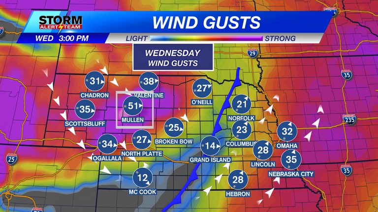
Residents across Nebraska should prepare for a windy start to the week. Today, southwest to northwest winds are expected to gust between 35 and 50 mph, with the strongest gusts hitting the Sandhills region. The same pattern will continue into Friday, with gusts likely to exceed 40‑45 mph.
What to Expect Thursday
Thursday brings a welcome break. Winds will relax, allowing sunny skies to dominate the state. Temperatures will remain mild, ranging from the low 50s in the north to the upper 60s in the south.
Weekend Outlook
By Saturday, winds will pick up again, though they will be slightly less intense than earlier in the week, generally staying in the 30‑45 mph range. Saturday afternoon and evening present the best chance for light rain as a cold front moves through eastern and southeastern Nebraska. The front will also usher in cooler air behind it.
Looking ahead to the following week, a light rain‑snow mix is possible Tuesday into Wednesday across the eastern and southeastern portions of the state. Temperatures are expected to stay near the mid‑40s to upper 60s over the next ten days, with morning lows in the low 20s to low 30s.
Travel and Safety Tips
High winds can create hazardous driving conditions, especially for high‑profile vehicles and those traveling on exposed roadways. Motorists should reduce speed, keep a firm grip on the steering wheel, and allow extra stopping distance. Those planning outdoor activities should secure loose items and consider postponing any tasks that require stable conditions, such as construction or roofing work.
Fire weather concerns remain in the western part of the state due to dry conditions combined with gusty winds. Residents should follow local fire‑danger advisories and avoid open flames or activities that could spark a wildfire.
Forecast Summary
- Today & Friday: Wind gusts 35‑50 mph, strongest in the Sandhills.
- Thursday: Winds subside, sunny skies, high 50‑70°F.
- Saturday: Winds 30‑45 mph, best chance for light rain in the afternoon/evening.
- Early next week (Tue‑Wed): Light rain‑snow mix possible in eastern and southeastern Nebraska.
- Temperature range (next 10 days): Highs 47‑67°F, mornings 21‑32°F.
For the most up‑to‑date information, follow meteorologist Houston Hall on Facebook and YouTube at HHallWX.
Original reporting: KLKN-TV – News, Weather and Sports for Lincoln, Nebraska — read the source article.