Residents across Nebraska should prepare for a windy and warm stretch of weather this week. Meteorologist Houston Hall notes that high temperatures will range from the low‑50s in the west to the mid‑60s in the east, while morning lows stay between the mid‑20s and mid‑30s.
Windy start to the week
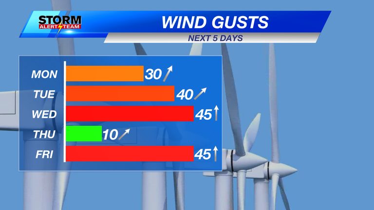
From Monday through Wednesday, southwest winds will dominate the forecast, with gusts expected to exceed 40‑45 mph on Tuesday and Wednesday. These breezy conditions will bring a cooling effect despite the warm daytime highs.
Thursday’s brief calm
Thursday offers a welcome break as winds subside and sunshine takes over most of the state. Temperatures will remain comfortable, staying near the mid‑50s to low‑60s.
Rain chances later in the week
Friday and Saturday will see winds pick up again, returning to gusts of 40‑45 mph. More importantly, the forecast calls for the highest probability of precipitation. A cold front moving in from the east will bring rain across eastern Nebraska, with the potential for mixed rain and snow in the western portions as colder air follows behind.
Wednesday evening may bring a few isolated showers in southeast Nebraska, but the coverage will be sparse. The real focus for rain is Friday night through Saturday morning, when the best chance for measurable precipitation is expected.
Looking ahead
High temperatures are projected to stay in the 54‑68 °F range over the next ten days, while morning lows will hover between 25‑36 °F. Windy conditions are likely to persist through Wednesday, ease on Thursday, and then return on Friday and Saturday.
Thanksgiving week could bring additional rain and cooler temperatures across the state, so residents should stay tuned for updates as the pattern evolves.
For the most current information, follow Houston Hall on Facebook and YouTube at HHallWX.
Original reporting: KLKN-TV – News, Weather and Sports for Lincoln, Nebraska — read the source article.