Residents of the Billings area enjoyed a milder than average Saturday, with temperatures hovering around 10 degrees above the typical November norm. While most of the region stayed dry, far western Montana experienced light rain showers and mountain snow as a weak disturbance moved across the northern Rockies.
Sunday: Warm and Partly Cloudy
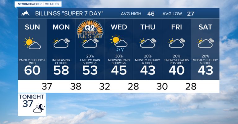
Tonight, cloud cover will gradually decrease, especially east of the Continental Divide, allowing for a clear night and comfortable lows. A ridge of high pressure will dominate Montana and Wyoming on Sunday, keeping skies partly cloudy and temperatures well above average. Isolated showers are still possible west of the Divide, but most areas can expect pleasant daytime highs.
Monday: Clouds Build from West to East
A Pacific trough will begin pushing inland on Sunday night, increasing cloud cover across the state on Monday. The westernmost portions of Montana will see a mix of rain and snow, while the majority of the region will remain dry for a little longer.
Mid‑Week Cooling Trend
By Tuesday and early Wednesday, the disturbance will move over the northern Rockies, bringing cooler air into the area. This shift will convert much of the rain into snow, particularly in the eastern parts of the state where temperatures will stay just warm enough for rain only. The storm’s intensity has weakened compared with earlier forecasts, so snowfall totals are expected to be modest.
Later in the Week
Thursday looks set for a quieter pattern, with limited snow shower activity. By Friday, the system will have moved out, leaving the region with clearer skies and a return to milder conditions.
Overall, the Billings area can look forward to a comfortable weekend followed by a brief period of cooler, cloudier weather early next week. Residents should stay tuned to local forecasts for any updates on precipitation, especially in western Montana where rain and snow are still possible.
Original reporting: KTVQ Q2 Billings (local) — read the source article.