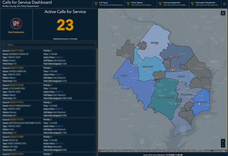
Fairfax County residents now have a new way to watch police activity in their neighborhoods. On Friday, Nov. 13, the Fairfax County Police Department (FCPD) released three online dashboards that display active calls for service, as well as historic drone and helicopter missions.
Calls for Service dashboard
The primary dashboard, called Calls for Service, shows a near‑real‑time map of police responses across the county. Each incident is marked with a brief description of the call type and an icon indicating whether air support—either a drone or a helicopter—is involved. The department stresses that the information is preliminary; call takers assign an initial type based on the first details they receive, and updates made by officers or dispatchers may not appear before the call is closed.
Because of this, FCPD advises residents not to treat the displayed call types as confirmed crimes or final classifications, and cautions against using the map to gauge overall crime trends. For official crime statistics and historical reporting, the department points users to its Open Data Portal.
Drone and helicopter mission dashboards
In addition to the live call map, the agency introduced two historical aviation tools: the Drone as First Responder (DFR) Missions Dashboard and the Police Helicopter Missions Dashboard. Both dashboards list every drone and helicopter flight since Oct. 1, 2026, showing the mission type and the police district or fire station that requested the support. The goal is to help the public understand how aerial assets are employed to protect safety across Fairfax County.
While the dashboards provide mission details, the department did not specify how precisely each flight is mapped—whether at the block level or a broader neighborhood view—to protect privacy. It also did not clarify whether certain sensitive calls, such as domestic disputes, medical emergencies, juvenile cases or active tactical operations, are automatically filtered from public view.
Connecting community cameras
FCPD reminded residents that they can voluntarily register home or business security cameras through the Connect Fairfax County program. Registered cameras can be identified by detectives during investigations, helping locate missing persons or gather evidence.
What remains unknown
The agency did not say whether older flight records will eventually be added to the drone and helicopter dashboards, nor did it disclose the cost of developing and maintaining these platforms. As the tools roll out, the department encourages community members to use them as a supplement to, not a replacement for, official crime data.
Overall, the new dashboards reflect Fairfax County’s commitment to transparency and community engagement, giving residents a clearer picture of public‑safety operations while maintaining necessary privacy safeguards.
Original reporting: Arlington County | FOX 5 DC — read the source article.