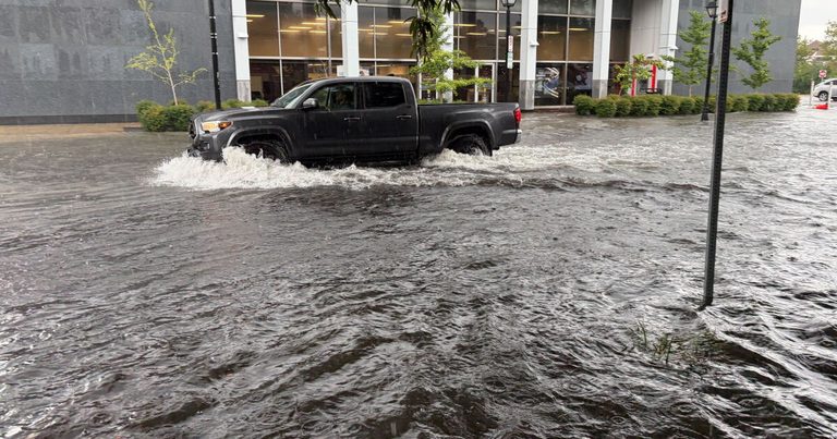
Norfolk City Council unanimously approved a $1.5 million contract with the U.S. Army Corps of Engineers on Tuesday to study coastal storm‑risk protections for Southside communities, including Berkley, Campostella, Campostella Heights, Diggs Town and Oakwood, according to WHRO. The study comes after three heavy rain events on Aug. 4, Aug. 22 and Nov. 6 that stranded cars and flooded roadways, underscoring the urgency for residents who have long endured water‑logged streets and underpasses.
The city’s after‑action report on the Aug. 4 storm noted that more than six inches of rain fell near Ghent, causing the Colley Avenue, Monticello Avenue and Virginia Beach Boulevard underpasses to flood, while about two feet of water pooled at Tidewater Drive and Wall Street. WHRO reported that Public Works staff said they could not recall all three major underpasses flooding simultaneously in at least 23 years.
Current pump‑upgrade efforts focus on replacing aging equipment within existing system limits rather than expanding capacity for stronger storms or sea‑level rise. At Colley Avenue, a $1.63 million plan to replace pumps, relocate electrical gear and widen street drains is slated for the 2028 budget, WHRO noted. Virginia Beach Boulevard’s pump station, built for severe storms, relies on a drainage pond that can overflow; a second pond approved in 2021 will not be funded until the 2028 or 2029 budget, depending on community outreach.
At Tidewater Drive and Wall Street, final designs are underway to upgrade electrical components, but the station’s capacity falls short of the inflow from a two‑year storm, according to the report. Monticello Avenue’s major upgrades are not scheduled in the five‑year budget, and debris buildup in its underground holding chamber continues to slow water flow.
To mitigate immediate problems, Norfolk launched a citywide cleaning program for underground pump chambers in January. Five stations have been cleaned, and a contractor is being arranged to clean the Hampton Boulevard chamber by year‑end. WHRO cited city logs showing the Hampton station kept water 4.4 feet below road level during the August storm while running two of its three pumps, and that its third pump has not been needed since May 22, 2026.
Parallel to these upgrades, the city is constructing the St. Paul’s Blue‑Greenway, replacing roughly 1,200 feet of buried concrete drainage tunnels with an open waterway and wetlands to capture runoff from 330 acres in the Newton’s Creek watershed. The project, funded by state, federal and city money, is expected to be completed in late 2028.
Ian Blair, policy program director at Wetlands Watch, warned that Norfolk’s drainage pipes were designed using outdated 2000‑era precipitation data, noting an 18 % increase in rainfall intensity and frequency in Virginia. Blair observed that heavy rain often coincides with high tides—such as the 3.19‑foot tide during the Aug. 4 storm—compounding drainage challenges. He urged better coordination between storm‑water and coastal‑surge planners, saying the water “has no place to go except on the street and the pools and the intersections and in the underpasses.”
What’s next: The $1.5 million study will be conducted over the next two years, with a draft report expected by early 2028. City officials plan to present funding recommendations for pump upgrades and additional drainage projects at the 2028 budget hearing. Residents are encouraged to attend the public outreach sessions scheduled for March and April, where officials will outline proposed solutions and gather community input.
Sources: whro.org