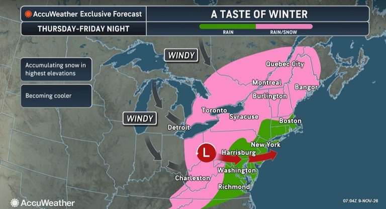
Higher elevations across the Northeast are set to receive the region’s first accumulating snowfall later this week as a developing storm moves eastward from Thursday into Saturday morning. The system will affect parts of Pennsylvania, West Virginia, New York and New England, bringing a mix of rain, snow and gusty winds that could make travel hazardous.
Where snow is most likely
Forecasters highlight that the greatest chances for accumulation are in the higher terrain of western Pennsylvania, along the Pennsylvania‑New York state line, and throughout the Catskill Mountains. Areas surrounding Erie, Pennsylvania, are also under watch. In West Virginia and the southwestern tip of Virginia, elevations above 2,000 feet could see measurable snow and slick roadways.
Impact on drivers
Travelers on elevated routes should expect slick surfaces, reduced visibility and potentially icy conditions through Saturday morning. The National Weather Service warns that even a thin layer of snow can turn wet pavement into a treacherous surface, especially on bridges and mountain passes.
AccuWeather expert meteorologist Tyler Roys explained, “There can be a very fine line between rain, snow and accumulating snow when temperatures are in the mid‑30s. Heavier precipitation can briefly cool the air enough for rain to change over to snow, while lighter rain or drizzle may never make that transition. That means two communities just a short distance apart could experience very different conditions.”
Temperature feel
Real‑feel temperatures are expected to run roughly 10 to 15 degrees colder than the actual thermometer readings, making the cold feel more biting than the numbers suggest. Residents should dress warmly and keep an emergency kit in their vehicles.
What to watch
In northern and western New England, snow is forecast along mountain ridges from northwestern Connecticut through western Massachusetts into Vermont. Drivers on these routes should anticipate slick conditions and possible road closures if snowfall intensifies.
Overall, the storm’s mixed precipitation and gusty winds could create hazardous travel conditions across a broad swath of the Northeast. Motorists are encouraged to check local forecasts, allow extra travel time, and consider postponing non‑essential trips until conditions improve.
Original reporting: Tampa Free Press — read the source article.