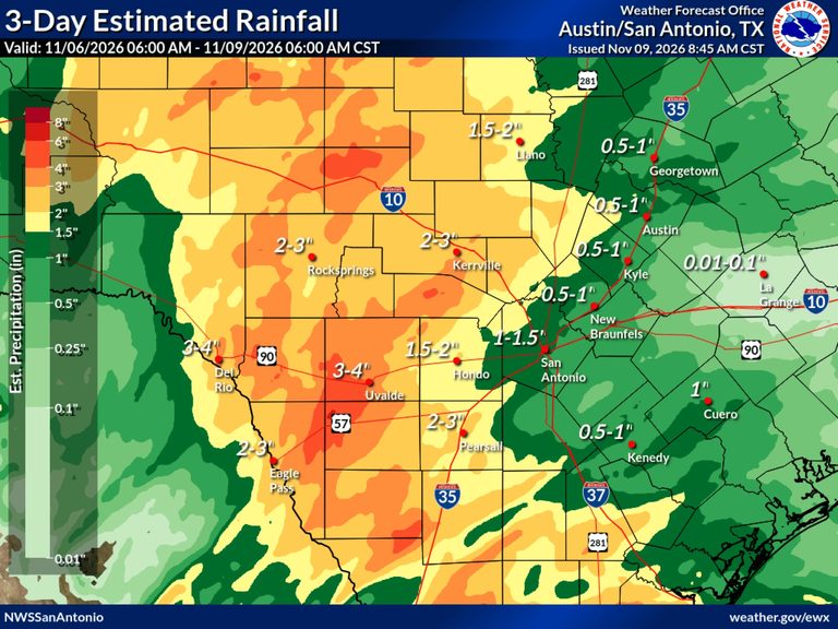
San Antonio saw a welcome break in the drought this weekend as the National Weather Service reported roughly an inch‑and‑half of rain fell west of I‑35 over a three‑day period ending at 7 a.m. Monday. The eastern side of Bexar County received less, but the overall totals helped ease the dry conditions that have plagued the region.
Road closures and local impacts
Despite the precipitation, a handful of city streets remained closed on Monday afternoon. Motorists are urged to check the latest local road‑closure updates before traveling. The lingering wet conditions also kept a flood advisory in effect until 4 p.m. Monday for Bandera, Edwards, Kerr, Kinney, Medina, Real and Uvalde counties, where creeks, streams and low‑water crossings were still at risk.
Regional flood warnings
Further west, a flood warning was issued for the Devils River near Comstock in Val Verde County, with officials expecting the river to crest about a foot above flood stage late Monday afternoon. South of the Alamo City, a broad swath of rain—ranging from four to eight inches, with an additional one to three inches possible—prompted a flash‑flood watch that remained in effect until noon Monday for several counties west of Corpus Christi and along the border with Mexico, including the cities of Corpus Christi and Kingsville.
Upcoming weather outlook
The National Weather Service indicated that rain chances will shift southeastward out of the region beginning Tuesday night and moving into Wednesday morning. A brief warming trend is expected Wednesday, with high temperatures climbing toward 80 degrees. A weak cold front will then move across the area Wednesday night, bringing a drier airmass that should lead to cooler, more refreshing conditions on Thursday under sunny skies. A secondary front may arrive early Friday, reinforcing the dry and cooler air. Friday and Saturday mornings could see chilly lows in the Hill Country valleys, potentially dipping into the upper 30s.
Temperature forecast for the week
San Antonio’s highs will hover around 70 degrees for most of the work week, with sunrise lows in the 50s. Veterans Day on Wednesday is projected to be the warmest day, reaching near 80 degrees. Friday and Saturday mornings are expected to be the coolest, with highs just above 50 degrees.
What residents should do
Residents in flood‑prone areas should remain vigilant for any updates to advisories and warnings, especially in the counties listed above. Drivers should continue to monitor road‑closure notices and allow extra travel time where routes remain impacted. As the weather shifts to a drier pattern later in the week, outdoor activities can be planned with confidence, but it is wise to stay prepared for sudden temperature changes, particularly in the Hill Country’s low‑lying valleys.
Original reporting: San Antonio Report — read the source article.