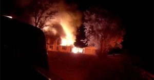
Residents of the Santa Clarita Valley, Santa Monica Mountains, Santa Susana Mountains, western San Gabriel Mountains and Orange County should prepare for heightened wildfire risk this weekend. The National Weather Service has issued a red flag warning that will be active from 2 a.m. to 6 p.m. Saturday.
What the warning means
A red flag warning signals that a combination of strong offshore winds, low humidity and warm temperatures creates conditions ripe for rapid fire spread. During the warning period, winds are expected to reach 20‑30 mph with gusts up to 45 mph, while relative humidity will dip to between 8% and 20%.
Forecast details
High pressure building off the coast will drive a warming trend through the weekend. In Los Angeles County, daytime highs are forecast to climb into the upper 70s and low 80s in coastal and valley areas, with many locations running 5‑10 degrees above normal on Saturday and Sunday. Orange County will see similar warmth, with lows in the low 80s on Friday and mid‑to‑upper 80s over the weekend.
Offshore flow will strengthen Friday and Saturday, producing weak‑to‑moderate Santa Ana winds in Orange County. Wind‑prone areas could experience gusts of 25‑40 mph Saturday, and there is a 10% chance of stronger gusts between 35‑50 mph.
Expert commentary
“We have high pressure out to our west, and this weather pattern is causing Santa Ana winds to develop,” explained NBC4 meteorologist Belen De Leon. “These are offshore winds that blow from the mountains out toward the coast. When that happens, it has a compressional effect on the air, and it causes those numbers to warm.”
De Leon added, “These winds are not going to be widespread, but they will lower out humidity and increase our risk for fire danger.”
Beach and tide outlook
A Beach Hazards Statement remains in effect through Tuesday morning for Catalina Island, the Malibu coast and Los Angeles County beaches. Dangerous rip currents and breaking waves of 4‑6 feet are expected. High tides will build each morning, peaking Sunday and Monday at 7.2‑7.6 feet.
What residents can do
Authorities urge residents to clear flammable debris from around homes, keep fire‑igniting equipment in good condition, and stay informed of any local fire‑danger updates. Those planning outdoor activities should monitor wind conditions and avoid open flames.
The offshore flow is expected to weaken by Tuesday, followed by a gradual cooling trend. Temperatures will likely remain above normal through Wednesday, but fire‑danger conditions should improve as winds subside.
Original reporting: NBC4 Los Angeles — read the source article.