Collin County officials announced that the study of the Outer Loop’s southeastern segments is nearing completion, bringing the long‑planned 14‑mile freeway corridor a step closer to final design and environmental clearance. The update follows a public meeting held on Oct. 27 at Leland Edge Middle School in Nevada, which was also streamed online for residents who could not attend in person.
Preferred Alignment Identified
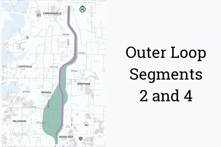
The county’s project team has settled on the “Pink Alignment,” a western‑shifted route that runs from County Road 656 northeast of Farmersville to the Collin‑Rockwall County line northwest of Royse City. This alignment updates the earlier Technically Preferred Alignment established in 2009 for Segment 2 (U.S. 380 to FM 6) and 2010 for Segment 4 (FM 6 to the Rockwall line), incorporating new development patterns and other constraints that have emerged over the past decade.
Schematic Design and Environmental Review
Engineers are now finalizing the schematic design and the Local Environmental Document (LED) for the preferred alignment. The LED will evaluate potential impacts on homes, businesses, community facilities, and archaeological, historical, cultural, and biological resources. Once the Collin County Commissioners Court reviews and approves the LED, the county will move into detailed design and begin acquiring the right‑of‑way needed for the corridor.
The proposed right‑of‑way would be roughly 500 feet wide, though exact property requirements may shift as engineering progresses. Preliminary work will determine lane configurations, ramp locations, interchange designs, drainage plans, and the amount of land required.
Phased Construction Plan
While no firm construction start date has been set for the full freeway, the county plans to build the project in phases. The first phase would consist of a two‑lane frontage road carrying traffic in both directions once funding is secured. Both frontage roads could be constructed simultaneously if traffic demand and available funds justify it. The main freeway lanes, designed for higher speeds, would be added later as population growth, development, and traffic volumes increase.
Design speeds are currently set at 45 mph for the frontage roads and 70 mph for the future main lanes, though these figures may be adjusted as engineering studies continue. Drainage will be managed through engineered grassy ditches, channels, and appropriately sized culverts to protect nearby neighborhoods.
Long‑Term Vision
When completed, the Outer Loop segment in Collin County will become part of a larger 55‑mile transportation corridor extending from the Denton County line through Celina, Weston, Anna, Melissa, Farmersville, Josephine, and Royse City. The corridor is intended to link with a regional outer‑loop system that would span Denton, Collin, Rockwall, Kaufman, and potentially Ellis counties.
Collin County is also advancing planning for Segments 1 and 5 of the Outer Loop and studying a separate north‑south freeway between Princeton and State Highway 121. Residents and property owners can track progress and view updated alignment maps at CCOL‑SE.com, where the county will post the most current information as the project evolves.
Community Impact and Support
The county’s approach emphasizes protecting the corridor from premature development by acquiring enough right‑of‑way for the ultimate freeway, not just the initial construction phase. This strategy aims to preserve the integrity of the transportation corridor for future generations while minimizing disruption to existing neighborhoods.
Local leaders stress that the Outer Loop will improve regional mobility, support economic growth, and provide a reliable transportation option for families and businesses throughout Collin County. As the project moves forward, officials encourage residents to stay informed, participate in upcoming public meetings, and share feedback through the county’s website.
Original reporting: Wylie News (HLL/CB) — read the source article.